Geolocate

Fatxes topographic map

Click on the map to display elevation.

About this map

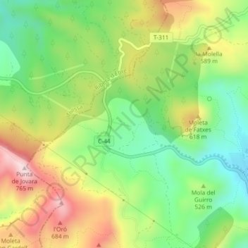
Name: Fatxes topographic map, elevation, terrain.

Location: Fatxes, Vandellòs i l'Hospitalet de l'Infant, Bajo Campo, Tarragona, Cataluña, España (41.02356 0.78506 41.04356 0.80506)

Average elevation: 503 m

Minimum elevation: 321 m

Maximum elevation: 748 m

Other topographic maps

Click on a map to view its topography, its elevation and its terrain.

Gear up for your next adventure:

🧰Multitool Knife - Compact and versatile tool for outdoor use
🥾All-Terrain Hiking Boots - Versatile boots for varied hiking conditions
🛌Down Sleeping Bag - Superior warmth-to-weight ratio for cold nights
🦌Outdoor Trail Camera - Monitor wildlife activity near your favorite spots
Family Camping Tent - Spacious tent suitable for family camping trips

As an Amazon Associate, this site earns from qualifying purchases at no extra cost to you.