
Perth topographic map
Click on the map to display elevation.
About this map
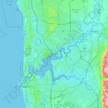
Name: Perth topographic map, elevation, terrain.
Location: Perth, Western Australia, 6000, Australia (-32.11590 115.70058 -31.79590 116.02058)
Average elevation: 26 m
Minimum elevation: -2 m
Maximum elevation: 288 m
Other topographic maps
Click on a map to view its topography, its elevation and its terrain.
Purnululu National Park
The Bungle Bungle Range, lying fully within the park, has elevations as high as 578 metres (1,896 ft) above sea level. It is famous for the sandstone domes, unusual and visually striking with their striping in alternating orange and grey bands. The banding of the domes is due to differences in clay content and…
Average elevation: 277 m
Mount Barker
The peak of Mount Barker lies 3.5 kilometres (2.2 mi) southwest of the town centre, and reaches an elevation of 404 metres (1,325 ft) above sea level. A sealed road leads to the base of a radio and television tower on the summit of the hill. The tower was constructed to a height of 168 metres (551 ft) in 1966,…
Average elevation: 211 m
Exmouth
In 2009, an emergency landing of the flight Qantas 72 was made at the nearby Learmonth Airport / RAAF Base Learmonth. The A330 had an incident involving the ADIRU which confused AoA (Angle of Attack) data with altitude data, making the plane think it was in a 16° pitch up when it was flying level. So the…
Average elevation: 27 m