Geolocate

Bethalto topographic map

Click on the map to display elevation.

About this map

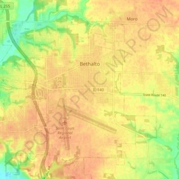
Name: Bethalto topographic map, elevation, terrain.

Location: Bethalto, Madison County, Illinois, United States (38.86992 -90.08195 38.93116 -90.01117)

Average elevation: 157 m

Minimum elevation: 131 m

Maximum elevation: 168 m

Other topographic maps

Click on a map to view its topography, its elevation and its terrain.

North Venice

United States > Illinois > Madison County > Venice

Average elevation: 126 m

North Alton

United States > Illinois > Madison County > Godfrey

Average elevation: 179 m

Bethalto

United States > Illinois > Madison County > Bethalto > Bethalto

Average elevation: 156 m

Alton

United States > Illinois > Madison County > Alton

Average elevation: 147 m

Gear up for your next adventure:

🧢Hiking Hat - Sun-protective and breathable hats for long treks
🧤Insulated Winter Gloves - Heavy-duty protection for sub-zero Canadian adventures
🧥Waterproof Jacket - Lightweight rain jackets for hiking and outdoor activities
🥾Light Trekking Boots - Supportive boots for multi-day treks
🧭GPS Outdoor Watch - Smart watch for navigation and fitness tracking in nature

As an Amazon Associate, this site earns from qualifying purchases at no extra cost to you.