Geolocate

Kodathi topographic map

Click on the map to display elevation.

About this map

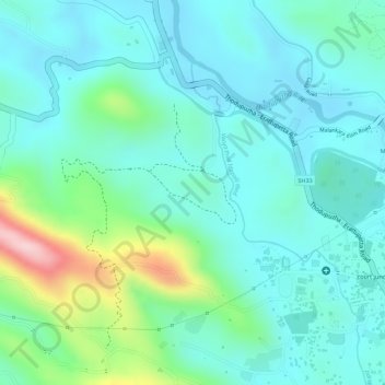
Name: Kodathi topographic map, elevation, terrain.

Location: Kodathi, Thodupuzha, Idukki, Kerala, India (9.84281 76.71946 9.85634 76.74139)

Average elevation: 87 m

Minimum elevation: 28 m

Maximum elevation: 279 m

Other topographic maps

Click on a map to view its topography, its elevation and its terrain.

Muttukadu

India > Kerala > Idukki

Average elevation: 1,096 m

Mattupetty Dam

India > Kerala > Idukki

Average elevation: 1,665 m

Pettimudi Hill Top

India > Kerala > Idukki

Average elevation: 810 m

Muthirapuzha

India > Kerala > Idukki

Average elevation: 551 m

Malankara Dam

India > Kerala > Idukki

Average elevation: 59 m

Idukki Dam

India > Kerala > Idukki

Average elevation: 701 m

Silent vally thodu

India > Kerala > Idukki

Average elevation: 1,668 m

Chokramudi

India > Kerala > Idukki

Average elevation: 1,670 m

Gear up for your next adventure:

🦟Insect Repellent - Keep mosquitoes and black flies away in wooded areas
🧰Survival Kit - Essential gear for emergencies in the wilderness
🧰Multitool Knife - Compact and versatile tool for outdoor use
🛏️Sleeping Bag - Warm and compact sleeping bags for outdoor camping
🔦LED Flashlight - Powerful and long-lasting flashlight for camping and emergencies

As an Amazon Associate, this site earns from qualifying purchases at no extra cost to you.