Geolocate

Baag topographic map

Click on the map to display elevation.

About this map

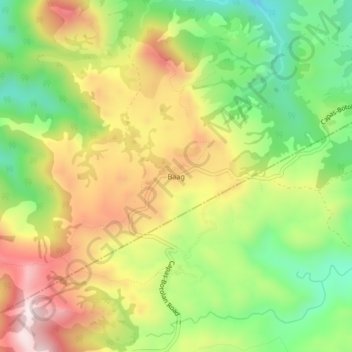
Name: Baag topographic map, elevation, terrain.

Location: Baag, San Jose, Tarlac, Central Luzon, Philippines (15.37381 120.37584 15.41381 120.41584)

Average elevation: 438 m

Minimum elevation: 200 m

Maximum elevation: 710 m

Other topographic maps

Click on a map to view its topography, its elevation and its terrain.

Bulsa River

Philippines > Tarlac > San Jose

Average elevation: 99 m

Gear up for your next adventure:

👖Convertible Hiking Pants - Zip-off legs to adapt to changing weather conditions
🥾Lightweight Hiking Boots - Boots for comfort and mobility on long hikes
🛰️Satellite Messenger - Emergency communication for areas with no cell service
🦶Hiking Shoe Insoles - Added support for high arches and long days on feet
🥾Trail Running Shoes - Lightweight and durable shoes for trail running

As an Amazon Associate, this site earns from qualifying purchases at no extra cost to you.