
Thank you for supporting this site ❤️
Make a donation
Make a donation
Gear up for your next adventure:
As an Amazon Associate, this site earns from qualifying purchases at no extra cost to you.
Plagne Soleil topographic map
Click on the map to display elevation.
Thank you for supporting this site ❤️
Make a donation
Make a donation
Gear up for your next adventure:
As an Amazon Associate, this site earns from qualifying purchases at no extra cost to you.
About this map
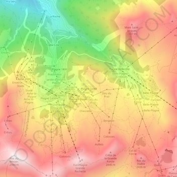
Name: Plagne Soleil topographic map, elevation, terrain.
Average elevation: 2,094 m
Minimum elevation: 1,453 m
Maximum elevation: 2,561 m
Thank you for supporting this site ❤️
Make a donation
Make a donation
Gear up for your next adventure:
As an Amazon Associate, this site earns from qualifying purchases at no extra cost to you.
Other topographic maps
Click on a map to view its topography, its elevation and its terrain.
Mâcot-la-Plagne
France > Auvergne-Rhône-Alpes > Savoie > La Plagne-Tarentaise
La commune de Mâcot-la-Plagne se situe au cœur de la Tarentaise sur le versant de l'Ubac et s'étage de 600 à 2 700 mètres d'altitude.
Average elevation: 1,780 m