
Make a donation
Gear up for your next adventure:
As an Amazon Associate, this site earns from qualifying purchases at no extra cost to you.
Alaka‘i Swamp topographic map
Click on the map to display elevation.
Make a donation
Gear up for your next adventure:
As an Amazon Associate, this site earns from qualifying purchases at no extra cost to you.
Alaka‘i Swamp
The Alakaʻi Wilderness Preserve, popularly known as Alakaʻi Swamp, is a montane wet forest on the Hawaiian island of Kauaʻi. Although the preserve is home to alpine bogs, it is not a true swamp.[1] It is located on a plateau near Mount Waiʻaleʻale, one of the wettest spots on Earth. Due to its unique combination of high elevation and climate, the Alakaʻi Swamp harbors a large number of endangered endemic species that are only found in this area and whose population has been dramatically declining over the last decades.[2] It is designated as a IUCN protected area.
Make a donation
Gear up for your next adventure:
As an Amazon Associate, this site earns from qualifying purchases at no extra cost to you.
About this map
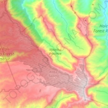
Name: Alaka‘i Swamp topographic map, elevation, terrain.
Location: Alaka‘i Swamp, Kauaʻi County, Hawaii, United States (22.05593 -159.62824 22.16043 -159.49357)
Average elevation: 899 m
Minimum elevation: 44 m
Maximum elevation: 1,586 m
Make a donation
Gear up for your next adventure:
As an Amazon Associate, this site earns from qualifying purchases at no extra cost to you.
Other topographic maps
Click on a map to view its topography, its elevation and its terrain.
Make a donation
Gear up for your next adventure:
As an Amazon Associate, this site earns from qualifying purchases at no extra cost to you.
Make a donation
Gear up for your next adventure:
As an Amazon Associate, this site earns from qualifying purchases at no extra cost to you.