
Thank you for supporting this site ❤️
Make a donation
Make a donation
Gear up for your next adventure:
As an Amazon Associate, this site earns from qualifying purchases at no extra cost to you.
Bhimavaram topographic map
Click on the map to display elevation.
Thank you for supporting this site ❤️
Make a donation
Make a donation
Gear up for your next adventure:
As an Amazon Associate, this site earns from qualifying purchases at no extra cost to you.
About this map
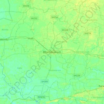
Name: Bhimavaram topographic map, elevation, terrain.
Location: Bhimavaram, West Godavari, Andhra Pradesh, 534200, India (16.38277 81.36734 16.70277 81.68734)
Average elevation: 6 m
Minimum elevation: -1 m
Maximum elevation: 13 m
Thank you for supporting this site ❤️
Make a donation
Make a donation
Gear up for your next adventure:
As an Amazon Associate, this site earns from qualifying purchases at no extra cost to you.