
Make a donation
Gear up for your next adventure:
As an Amazon Associate, this site earns from qualifying purchases at no extra cost to you.
Payún Matrú topographic map
Click on the map to display elevation.
Make a donation
Gear up for your next adventure:
As an Amazon Associate, this site earns from qualifying purchases at no extra cost to you.
Payún Matrú
Payún Matrú lies in the Malargüe Department of the Mendoza Province, in Argentina. The area is inhospitable due to the lack of usable water and high elevation. Nevertheless, there are many paved roads such as National Route 40 which passes west of the field, and National Route 186 which runs around its northern and eastern parts. The volcano is within the Reserva Provincial La Payunia. Owing to the variety of volcanic landforms, the province was included in the 2010 Tentative List of UNESCO World Heritage Sites and a number of potential geosites have been identified at Payún Matrú itself.
Make a donation
Gear up for your next adventure:
As an Amazon Associate, this site earns from qualifying purchases at no extra cost to you.
About this map
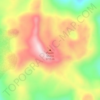
Name: Payún Matrú topographic map, elevation, terrain.
Average elevation: 3,462 m
Minimum elevation: 3,222 m
Maximum elevation: 3,665 m
Make a donation
Gear up for your next adventure:
As an Amazon Associate, this site earns from qualifying purchases at no extra cost to you.