Geolocate

Myrtle Creek topographic map

Click on the map to display elevation.

About this map

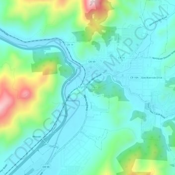
Name: Myrtle Creek topographic map, elevation, terrain.

Location: Myrtle Creek, Douglas County, Oregon, United States (42.99789 -123.31493 43.04192 -123.26039)

Average elevation: 277 m

Minimum elevation: 170 m

Maximum elevation: 661 m

Other topographic maps

Click on a map to view its topography, its elevation and its terrain.

Scottsburg

United States > Oregon > Douglas County

Average elevation: 168 m

Tenmile

United States > Oregon > Douglas County

Average elevation: 279 m

Umpqua

United States > Oregon > Douglas County

Average elevation: 137 m

Diamond Lake

United States > Oregon > Douglas County

Average elevation: 1,632 m

Dillard

United States > Oregon > Douglas County

Average elevation: 202 m

Rice Hill

United States > Oregon > Douglas County

Average elevation: 241 m

Glide

United States > Oregon > Douglas County

Average elevation: 259 m

Azalea

United States > Oregon > Douglas County

Average elevation: 604 m

Toketee Falls

United States > Oregon > Douglas County

Average elevation: 865 m

Tyee

United States > Oregon > Douglas County

Average elevation: 217 m

Wits End

United States > Oregon > Douglas County

Average elevation: 1,930 m

Azalea

United States > Oregon > Douglas County

Average elevation: 604 m

Gear up for your next adventure:

🧼Biodegradable Camp Soap - Environmentally friendly cleaning for gear and body
🍽️Titanium Camping Spork - Ultralight and indestructible eating utensil
🔭Compact Monocular - One-handed bird watching and trail spotting
🦌Outdoor Trail Camera - Monitor wildlife activity near your favorite spots
🥾Approach Shoes - Shoes designed for climbing approaches and rugged trails

As an Amazon Associate, this site earns from qualifying purchases at no extra cost to you.