Geolocate

Base Camp topographic map

Click on the map to display elevation.

About this map

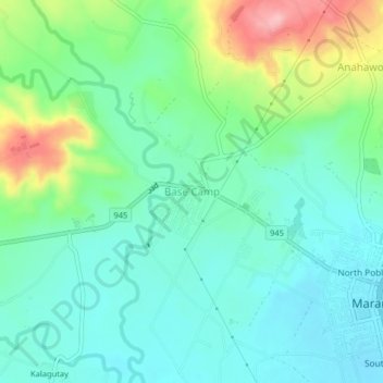
Name: Base Camp topographic map, elevation, terrain.

Location: Base Camp, Bukidnon, Northern Mindanao, 8714, Philippines (7.75280 124.96503 7.79280 125.00503)

Average elevation: 320 m

Minimum elevation: 274 m

Maximum elevation: 442 m

Other topographic maps

Click on a map to view its topography, its elevation and its terrain.

Quezon

Philippines > Bukidnon

Despite its being a first-class municipality, Quezon took some time to move forward with its development goals on account of the precarious peace situation in the area. Due in part to its mountainous topography, Quezon had been an ideal hotbed of communist movements that infiltrated the local government since…

Average elevation: 487 m

Valencia

Philippines > Bukidnon

The city's topography is characterized as flat to undulating hills with extensive plateaus and mountainous areas and cliffs on both eastern and western portions bounding the municipality of San Fernando on the east and the municipality of Talakag on the west. Its highest point is Mount Kalatungan in the…

Average elevation: 736 m

Gear up for your next adventure:

🧣Evaporative Cooling Towel - Beat the heat during intense summer climbs
🕯️Camping Lantern - Illuminates your entire campsite with high-efficiency LEDs
🧳Compression Sacks - Maximize space in your backpack by shrinking gear
💧Hydration Pack - Hands-free hydration system for long hikes
🥾Trail Hiking Socks - Comfortable socks to prevent blisters and fatigue

As an Amazon Associate, this site earns from qualifying purchases at no extra cost to you.