
Make a donation
Gear up for your next adventure:
As an Amazon Associate, this site earns from qualifying purchases at no extra cost to you.
Lac d'Aumar topographic map
Click on the map to display elevation.
Make a donation
Gear up for your next adventure:
As an Amazon Associate, this site earns from qualifying purchases at no extra cost to you.
About this map
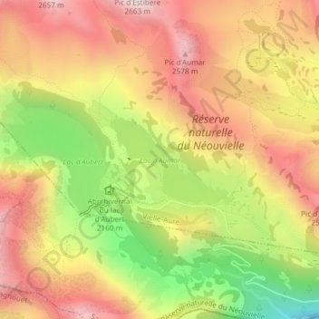
Name: Lac d'Aumar topographic map, elevation, terrain.
Average elevation: 2,280 m
Minimum elevation: 1,854 m
Maximum elevation: 2,608 m
Make a donation
Gear up for your next adventure:
As an Amazon Associate, this site earns from qualifying purchases at no extra cost to you.
Other topographic maps
Click on a map to view its topography, its elevation and its terrain.
Pic de Bastan
France > Occitanie > Hautes-Pyrénées > Vielle-Aure
Le pic de Bastan est un sommet des Pyrénées situé dans les Hautes-Pyrénées, et qui culmine à 2 715 mètres d'altitude. Il se trouve dans l'ouest du massif de l'Arbizon, entre la vallée d'Aure au sud-est, et la vallée de Campan au nord, dans la région de Bastan où se côtoient une succession de lacs.
Average elevation: 2,348 m
Make a donation
Gear up for your next adventure:
As an Amazon Associate, this site earns from qualifying purchases at no extra cost to you.