Geolocate

Pickerington topographic map

Click on the map to display elevation.

About this map

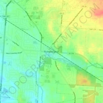
Name: Pickerington topographic map, elevation, terrain.

Location: Pickerington, Fairfield County, Ohio, 43147, United States (39.86423 -82.77350 39.90423 -82.73350)

Average elevation: 262 m

Minimum elevation: 241 m

Maximum elevation: 291 m

Gear up for your next adventure:

🔥Emergency Fire Starter - Reliable ignition source for all weather conditions
🧥Insulated Jacket - Keep warm in cold outdoor conditions
🐕Hiking Dog Pack - Let your canine companion carry their own water and food
🛌Down Sleeping Bag - Superior warmth-to-weight ratio for cold nights
🚲Handlebar Phone Mount - View topographic-map.com live while cycling

As an Amazon Associate, this site earns from qualifying purchases at no extra cost to you.