
Make a donation
Gear up for your next adventure:
As an Amazon Associate, this site earns from qualifying purchases at no extra cost to you.
Divinópolis topographic map
Click on the map to display elevation.
Make a donation
Gear up for your next adventure:
As an Amazon Associate, this site earns from qualifying purchases at no extra cost to you.
Divinópolis
Divinópolis is a municipality in the centre-west of Minas Gerais state, Brazil. The estimated population in 2020 was 240,408 inhabitants. The total area of the municipality is 709 km2 and the elevation is 712 metres. It is 120 km from state capital Belo Horizonte. Divinópolis is the seat of the Regional Administration of the Upper São Francisco River.
Make a donation
Gear up for your next adventure:
As an Amazon Associate, this site earns from qualifying purchases at no extra cost to you.
About this map
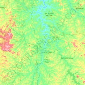
Name: Divinópolis topographic map, elevation, terrain.
Average elevation: 780 m
Minimum elevation: 654 m
Maximum elevation: 1,102 m
Make a donation
Gear up for your next adventure:
As an Amazon Associate, this site earns from qualifying purchases at no extra cost to you.
Other topographic maps
Click on a map to view its topography, its elevation and its terrain.
Itamarati
Brazil > Minas Gerais > Região Metropolitana de Belo Horizonte > Belo Horizonte
Average elevation: 831 m