Geolocate

Herston topographic map

Click on the map to display elevation.

About this map

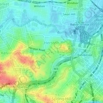
Name: Herston topographic map, elevation, terrain.

Location: Herston, City of Brisbane, Queensland, 4029, Australia (-27.45737 153.01478 -27.44072 153.03002)

Average elevation: 23 m

Minimum elevation: 3 m

Maximum elevation: 68 m

Other topographic maps

Click on a map to view its topography, its elevation and its terrain.

Bulimba Creek

Australia > Queensland > City of Brisbane

Average elevation: 11 m

Tangalooma

Australia > Queensland > City of Brisbane

Average elevation: 41 m

Enoggera Hill

Australia > Queensland > City of Brisbane

Average elevation: 114 m

Enoggera Dam

Australia > Queensland > City of Brisbane

Average elevation: 90 m

Blunder Creek

Australia > Queensland > City of Brisbane

Average elevation: 26 m

Tangalooma

Australia > Queensland > City of Brisbane

Average elevation: 41 m

Gear up for your next adventure:

💡Compact LED Flashlight - Powerful and portable flashlight for outdoor use
🛏️Sleeping Bag - Warm and compact sleeping bags for outdoor camping
🔨Vehicle Emergency Tool - Safety tool for remote road trips to trailheads
🧴Insect Repellent - Protect yourself from bugs during outdoor adventures
🔭Compact Monocular - One-handed bird watching and trail spotting

As an Amazon Associate, this site earns from qualifying purchases at no extra cost to you.