Geolocate

Decatur topographic map

Click on the map to display elevation.

About this map

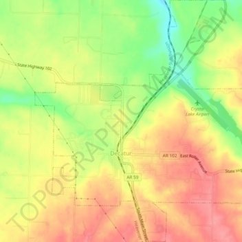
Name: Decatur topographic map, elevation, terrain.

Location: Decatur, Benton County, Arkansas, 72722, United States (36.32210 -94.47744 36.35985 -94.43075)

Average elevation: 379 m

Minimum elevation: 329 m

Maximum elevation: 414 m

Other topographic maps

Click on a map to view its topography, its elevation and its terrain.

Lake Frances

United States > Arkansas > Benton County

Average elevation: 318 m

Gear up for your next adventure:

🔦LED Headtorch - Bright and durable light for night activities
🕯️Camping Lantern - Illuminates your entire campsite with high-efficiency LEDs
🛌Insulated Sleeping Pad - Critical thermal barrier between you and the cold ground
🗺️Topographic Maps - Detailed maps to explore trails, mountains, and wilderness areas
🦶Hiking Shoe Insoles - Added support for high arches and long days on feet

As an Amazon Associate, this site earns from qualifying purchases at no extra cost to you.