
Make a donation
Gear up for your next adventure:
As an Amazon Associate, this site earns from qualifying purchases at no extra cost to you.
McHenry County topographic map
Click on the map to display elevation.
Make a donation
Gear up for your next adventure:
As an Amazon Associate, this site earns from qualifying purchases at no extra cost to you.
About this map
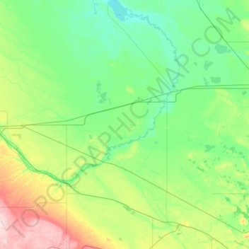
Name: McHenry County topographic map, elevation, terrain.
Location: McHenry County, North Dakota, United States (47.84705 -101.05954 48.63240 -100.19719)
Average elevation: 479 m
Minimum elevation: 431 m
Maximum elevation: 691 m
Make a donation
Gear up for your next adventure:
As an Amazon Associate, this site earns from qualifying purchases at no extra cost to you.
Other topographic maps
Click on a map to view its topography, its elevation and its terrain.
White Butte
United States > North Dakota > Slope County
White Butte is the highest natural point in the U.S. state of North Dakota. At an elevation of 3,506 ft (1,069 m), it is a prominent butte in Slope County, in the Badlands of the southwestern part of the state. It is located 3 miles (5 kilometers) east of U.S. 85 and about 6.5 mi (10 km) south of Amidon.
Average elevation: 974 m
Make a donation
Gear up for your next adventure:
As an Amazon Associate, this site earns from qualifying purchases at no extra cost to you.