
Hemer topographic map
Click on the map to display elevation.
Hemer
Hemer is located at the north end of the Sauerland near the Ruhr river. The highest elevation, at 546 metres (1,791 ft), is in the Balver Wald in the south of the city. The lowest elevation, at 160 metres (525 ft), is at the Edelburg in the northeast.
About this map
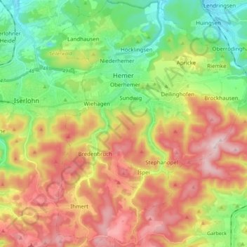
Name: Hemer topographic map, elevation, terrain.
Location: Hemer, Märkischer Kreis, North Rhine-Westphalia, 58675, Germany (51.31223 7.72022 51.41748 7.85342)
Average elevation: 326 m
Minimum elevation: 152 m
Maximum elevation: 547 m