
Thank you for supporting this site ❤️
Make a donation
Make a donation
Gear up for your next adventure:
As an Amazon Associate, this site earns from qualifying purchases at no extra cost to you.
Riedering topographic map
Click on the map to display elevation.
Thank you for supporting this site ❤️
Make a donation
Make a donation
Gear up for your next adventure:
As an Amazon Associate, this site earns from qualifying purchases at no extra cost to you.
About this map
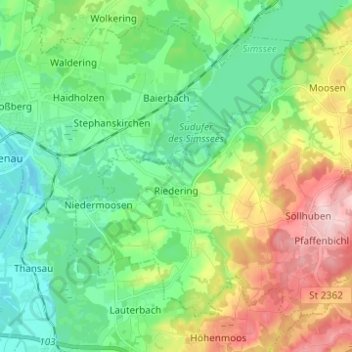
Name: Riedering topographic map, elevation, terrain.
Location: Riedering, Landkreis Rosenheim, Bayern, 83083, Deutschland (47.80963 12.16879 47.87600 12.29223)
Average elevation: 508 m
Minimum elevation: 438 m
Maximum elevation: 655 m
Thank you for supporting this site ❤️
Make a donation
Make a donation
Gear up for your next adventure:
As an Amazon Associate, this site earns from qualifying purchases at no extra cost to you.
Other topographic maps
Click on a map to view its topography, its elevation and its terrain.
Leonhardspfunzen
Deutschland > Bayern > Landkreis Rosenheim > Stephanskirchen
Average elevation: 472 m