
Make a donation
Gear up for your next adventure:
As an Amazon Associate, this site earns from qualifying purchases at no extra cost to you.
Garmisch-Partenkirchen topographic map
Click on the map to display elevation.
Make a donation
Gear up for your next adventure:
As an Amazon Associate, this site earns from qualifying purchases at no extra cost to you.
Garmisch-Partenkirchen
Garmisch-Partenkirchen leans towards an oceanic climate, and its winters are colder than the rest of Bavaria. Due to its higher elevation, it is very close to the winters associated with continental climates; it has a relatively wet and snowy climate, with high precipitation year-round. As of 2013 the regions in the west and east of the town were cited as having highest numbers of thunderstorm days in Europe.
Make a donation
Gear up for your next adventure:
As an Amazon Associate, this site earns from qualifying purchases at no extra cost to you.
About this map
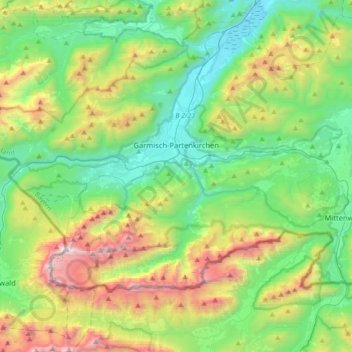
Name: Garmisch-Partenkirchen topographic map, elevation, terrain.
Average elevation: 1,326 m
Minimum elevation: 633 m
Maximum elevation: 2,945 m
Make a donation
Gear up for your next adventure:
As an Amazon Associate, this site earns from qualifying purchases at no extra cost to you.
Other topographic maps
Click on a map to view its topography, its elevation and its terrain.
Königshaus am Schachen
Germany > Bavaria > Landkreis Garmisch-Partenkirchen > Garmisch-Partenkirchen
The King's House on Schachen is located at Schachen, at an altitude with a view of the dramatic mountain backdrop of the Wetterstein Formation, about 10 km south of Garmisch-Partenkirchen, Bavaria. It can only be reached via a 10 km forest road, or a three-hour hike, ascending 1000m either from Schloss Elmau…
Average elevation: 1,629 m
Partnach Gorge
Germany > Bavaria > Landkreis Garmisch-Partenkirchen > Garmisch-Partenkirchen > Vordergraseck
Average elevation: 1,004 m
Schachen
Germany > Bavaria > Landkreis Garmisch-Partenkirchen > Garmisch-Partenkirchen
Average elevation: 1,636 m
Make a donation
Gear up for your next adventure:
As an Amazon Associate, this site earns from qualifying purchases at no extra cost to you.
Kramerspitz
Germany > Bavaria > Landkreis Garmisch-Partenkirchen > Garmisch-Partenkirchen
Average elevation: 1,438 m
Zugspitze
Germany > Bavaria > Landkreis Garmisch-Partenkirchen > Grainau
The mountain rises eleven kilometres southwest of Garmisch-Partenkirchen and just under six kilometres east of Ehrwald. The border between Germany and Austria runs over the west summit; thus the Zugspitze massif belongs to the German state of Bavaria and the Austrian state of Tyrol. The municipalities…
Average elevation: 2,300 m
Geroldsee (Wagenbrüchsee)
Germany > Bavaria > Landkreis Garmisch-Partenkirchen > Gerold
Average elevation: 1,040 m
Make a donation
Gear up for your next adventure:
As an Amazon Associate, this site earns from qualifying purchases at no extra cost to you.
Heimgarten
Germany > Bavaria > Landkreis Garmisch-Partenkirchen > Ohlstadt
Heimgarten (elevation 1,790 metres/5,870 ft) is a mountain near Ohlstadt in the Bavarian Prealps of southern Germany. It is connected via a ridge with Herzogstand (1,731 metres/5,679 ft) to the east.
Average elevation: 1,342 m
Zugspitze
Germany > Bavaria > Landkreis Garmisch-Partenkirchen > Grainau
The mountain rises eleven kilometres southwest of Garmisch-Partenkirchen and just under six kilometres east of Ehrwald. The border between Germany and Austria runs over the west summit; thus the Zugspitze massif belongs to the German state of Bavaria and the Austrian state of Tyrol. The municipalities…
Average elevation: 2,300 m