
Thank you for supporting this site ❤️
Make a donation
Make a donation
Gear up for your next adventure:
As an Amazon Associate, this site earns from qualifying purchases at no extra cost to you.
Oxwich topographic map
Click on the map to display elevation.
Thank you for supporting this site ❤️
Make a donation
Make a donation
Gear up for your next adventure:
As an Amazon Associate, this site earns from qualifying purchases at no extra cost to you.
About this map
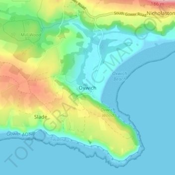
Name: Oxwich topographic map, elevation, terrain.
Location: Oxwich, Swansea, Wales, SA3 1LS, United Kingdom (51.53840 -4.18596 51.57840 -4.14596)
Average elevation: 36 m
Minimum elevation: -2 m
Maximum elevation: 143 m
Thank you for supporting this site ❤️
Make a donation
Make a donation
Gear up for your next adventure:
As an Amazon Associate, this site earns from qualifying purchases at no extra cost to you.