
Make a donation
Gear up for your next adventure:
As an Amazon Associate, this site earns from qualifying purchases at no extra cost to you.
Bronrome topographic map
Click on the map to display elevation.
Make a donation
Gear up for your next adventure:
As an Amazon Associate, this site earns from qualifying purchases at no extra cost to you.
About this map
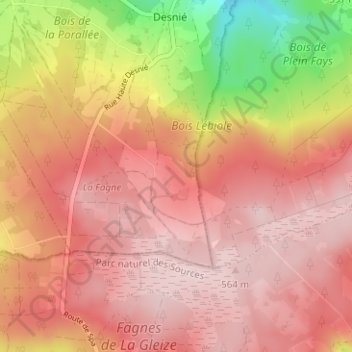
Name: Bronrome topographic map, elevation, terrain.
Location: Bronrome, La Reid, Theux, Verviers, Luik, Wallonië, 4910, België (50.42396 5.79210 50.46396 5.83210)
Average elevation: 483 m
Minimum elevation: 311 m
Maximum elevation: 565 m
Make a donation
Gear up for your next adventure:
As an Amazon Associate, this site earns from qualifying purchases at no extra cost to you.
Other topographic maps
Click on a map to view its topography, its elevation and its terrain.
Hoëgne
België > Luik > Verviers > Theux > Polleur > Nardaie de Polleur
De Hoëgne ontspringt op de hoogte van Mont Rigi in Sourbrodt, een deelgemeente van Weismes. Het riviertje draagt er de naam Rû de Polleur en neemt na een vijftal kilometer de Rû de Herbofaye op, die ontspringt in de buurt van de Baraque Michel.
Average elevation: 296 m
Make a donation
Gear up for your next adventure:
As an Amazon Associate, this site earns from qualifying purchases at no extra cost to you.