
Thank you for supporting this site ❤️
Make a donation
Make a donation
Gear up for your next adventure:
As an Amazon Associate, this site earns from qualifying purchases at no extra cost to you.
Bigod topographic map
Click on the map to display elevation.
Thank you for supporting this site ❤️
Make a donation
Make a donation
Gear up for your next adventure:
As an Amazon Associate, this site earns from qualifying purchases at no extra cost to you.
About this map
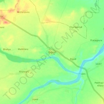
Name: Bigod topographic map, elevation, terrain.
Location: Bigod, Mandalgarh Tehsil, Bhilwara District, Rajasthan, India (25.21923 74.96894 25.29923 75.04894)
Average elevation: 363 m
Minimum elevation: 342 m
Maximum elevation: 389 m
Thank you for supporting this site ❤️
Make a donation
Make a donation
Gear up for your next adventure:
As an Amazon Associate, this site earns from qualifying purchases at no extra cost to you.