
Make a donation
Gear up for your next adventure:
As an Amazon Associate, this site earns from qualifying purchases at no extra cost to you.
Westover topographic map
Click on the map to display elevation.
Make a donation
Gear up for your next adventure:
As an Amazon Associate, this site earns from qualifying purchases at no extra cost to you.
About this map
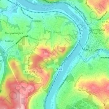
Name: Westover topographic map, elevation, terrain.
Location: Westover, Monongalia County, West Virginia, United States (39.61267 -79.99322 39.64358 -79.95920)
Average elevation: 298 m
Minimum elevation: 240 m
Maximum elevation: 390 m
Make a donation
Gear up for your next adventure:
As an Amazon Associate, this site earns from qualifying purchases at no extra cost to you.
Other topographic maps
Click on a map to view its topography, its elevation and its terrain.
South Hills
United States > West Virginia > Monongalia County > Morgantown > South Hills
Average elevation: 312 m
Make a donation
Gear up for your next adventure:
As an Amazon Associate, this site earns from qualifying purchases at no extra cost to you.