Geolocate

Margalef topographic map

Click on the map to display elevation.

About this map

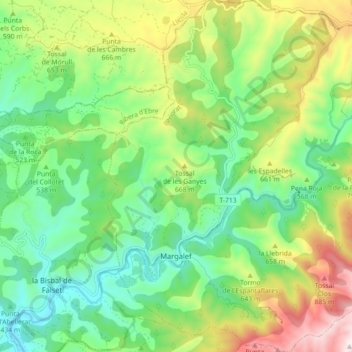
Name: Margalef topographic map, elevation, terrain.

Location: Margalef, Priorat, Tarragona, Catalonia, 43371, Spain (41.26717 0.73630 41.33428 0.81472)

Average elevation: 547 m

Minimum elevation: 309 m

Maximum elevation: 996 m

Other topographic maps

Click on a map to view its topography, its elevation and its terrain.

Porrera

Spain > Catalonia > Priorat > Porrera > Porrera

Average elevation: 430 m

Gear up for your next adventure:

💡Compact LED Flashlight - Powerful and portable flashlight for outdoor use
💧Collapsible Water Bottle - Space-saving water bottle for outdoor activities
👟Sport Hiking Sandals - Breathable footwear for water crossings and camp rest
Lightweight Camping Tent - Portable shelter optimized for Canadian backcountry camping
🥾Waterproof Hiking Shoes - Durable shoes for wet and rugged trails

As an Amazon Associate, this site earns from qualifying purchases at no extra cost to you.