Geolocate

Pio Duran topographic map

Click on the map to display elevation.

About this map

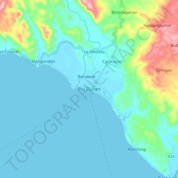
Name: Pio Duran topographic map, elevation, terrain.

Location: Pio Duran, Albay, Bicol Region, 4516, Philippines (12.98970 123.40314 13.06970 123.48314)

Average elevation: 43 m

Minimum elevation: 0 m

Maximum elevation: 232 m

Other topographic maps

Click on a map to view its topography, its elevation and its terrain.

Peñaranda Park

Philippines > Albay > Legazpi > Baño

Average elevation: 37 m

Malilipot

Philippines > Albay

Average elevation: 262 m

Rapu-Rapu

Philippines > Albay

Average elevation: 18 m

Gear up for your next adventure:

🚑Survival Whistle - Signal for help across long distances in mountains
🪑Ultralight Camping Stool - Compact seating for rest stops during long hikes
🧤Thermal Hiking Gloves - Grip-enhanced gloves for cold-weather altitude trekking
💧Filtered Water Bottle - Safe drinking water on the go
🥾Waterproof Trail Shoes - Shoes designed to handle wet terrain

As an Amazon Associate, this site earns from qualifying purchases at no extra cost to you.