
Make a donation
Gear up for your next adventure:
As an Amazon Associate, this site earns from qualifying purchases at no extra cost to you.
Martinborough Community topographic map
Click on the map to display elevation.
Make a donation
Gear up for your next adventure:
As an Amazon Associate, this site earns from qualifying purchases at no extra cost to you.
About this map
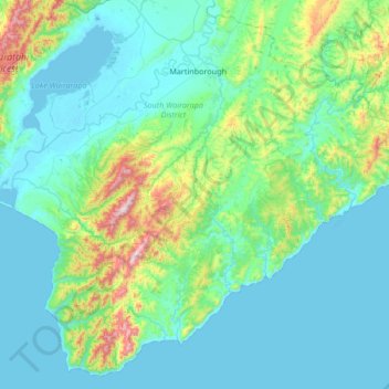
Name: Martinborough Community topographic map, elevation, terrain.
Average elevation: 141 m
Minimum elevation: -2 m
Maximum elevation: 968 m
Make a donation
Gear up for your next adventure:
As an Amazon Associate, this site earns from qualifying purchases at no extra cost to you.
Other topographic maps
Click on a map to view its topography, its elevation and its terrain.
Hinakura
New Zealand > Wellington > South Wairarapa District > Martinborough Community
Average elevation: 86 m
Ngāwī
New Zealand > Wellington > South Wairarapa District > Martinborough Community
Average elevation: 97 m
Waipawa
New Zealand > Wellington > South Wairarapa District > Martinborough Community
Average elevation: 165 m