
Thank you for supporting this site ❤️
Make a donation
Make a donation
Gear up for your next adventure:
As an Amazon Associate, this site earns from qualifying purchases at no extra cost to you.
Ward 44 topographic map
Click on the map to display elevation.
Thank you for supporting this site ❤️
Make a donation
Make a donation
Gear up for your next adventure:
As an Amazon Associate, this site earns from qualifying purchases at no extra cost to you.
About this map
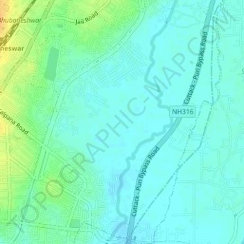
Name: Ward 44 topographic map, elevation, terrain.
Average elevation: 21 m
Minimum elevation: 13 m
Maximum elevation: 42 m
Thank you for supporting this site ❤️
Make a donation
Make a donation
Gear up for your next adventure:
As an Amazon Associate, this site earns from qualifying purchases at no extra cost to you.
Other topographic maps
Click on a map to view its topography, its elevation and its terrain.
Netaji Subash chandra Bose Park
India > Odisha > Bhubaneswar (M.Corp.) > Bhubaneswar Municipal Corporation
Average elevation: 34 m
Rajiv Nagar
India > Odisha > Bhubaneswar (M.Corp.) > Bhubaneswar Municipal Corporation
Average elevation: 36 m