Geolocate

Mekarsari topographic map

Click on the map to display elevation.

About this map

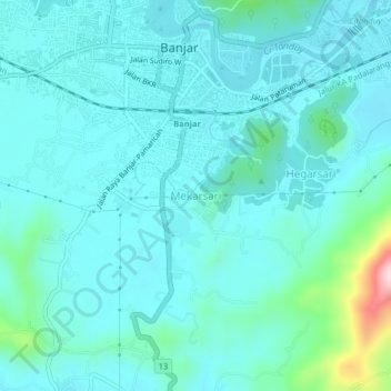
Name: Mekarsari topographic map, elevation, terrain.

Location: Mekarsari, Banjar, West Java, Java, 46322, Indonesia (-7.40488 108.52324 -7.36488 108.56324)

Average elevation: 58 m

Minimum elevation: 13 m

Maximum elevation: 330 m

Other topographic maps

Click on a map to view its topography, its elevation and its terrain.

Purwaharja

Indonesia > West Java > Banjar

Average elevation: 44 m

Banjar

Indonesia > West Java > Banjar

Average elevation: 65 m

Langensari

Indonesia > West Java > Banjar

Average elevation: 19 m

Pataruman

Indonesia > West Java > Banjar

Average elevation: 53 m

Binangun

Indonesia > West Java > Banjar

Average elevation: 56 m

Gear up for your next adventure:

🛶Kayak Dry Bag - Waterproof storage for kayaking adventures
🕶️Polarized Sunglasses - Protect your eyes with durable polarized lenses
🦟Insect Repellent - Keep mosquitoes and black flies away in wooded areas
💡Compact LED Flashlight - Powerful and portable flashlight for outdoor use
🧣Merino Neck Gaiter - Protects against wind, sun, and cold at high altitudes

As an Amazon Associate, this site earns from qualifying purchases at no extra cost to you.