Geolocate

Frades topographic map

Click on the map to display elevation.

About this map

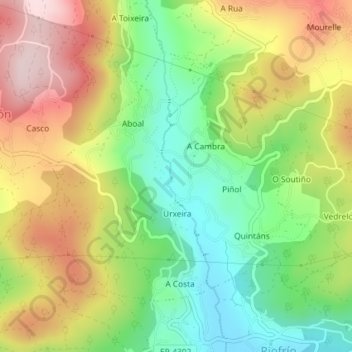
Name: Frades topographic map, elevation, terrain.

Location: Frades, Mondariz, Condado, Pontevedra, Galicia, España (42.24195 -8.48690 42.26106 -8.46014)

Average elevation: 205 m

Minimum elevation: 52 m

Maximum elevation: 390 m

Gear up for your next adventure:

🪑Ultralight Camping Stool - Compact seating for rest stops during long hikes
❄️Traction Ice Cleats - Slip-on spikes for icy trails and winter hiking
🧣Merino Neck Gaiter - Protects against wind, sun, and cold at high altitudes
🧥Packable Rain Jacket - Breathable waterproof layer for unpredictable weather
🧼Biodegradable Camp Soap - Environmentally friendly cleaning for gear and body

As an Amazon Associate, this site earns from qualifying purchases at no extra cost to you.