
Thank you for supporting this site ❤️
Make a donation
Make a donation
Gear up for your next adventure:
As an Amazon Associate, this site earns from qualifying purchases at no extra cost to you.
Ccallipata topographic map
Click on the map to display elevation.
Thank you for supporting this site ❤️
Make a donation
Make a donation
Gear up for your next adventure:
As an Amazon Associate, this site earns from qualifying purchases at no extra cost to you.
About this map
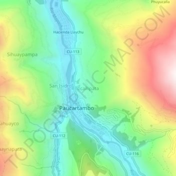
Name: Ccallipata topographic map, elevation, terrain.
Location: Ccallipata, Paucartambo, Cusco, Perú (-13.33313 -71.61331 -13.29313 -71.57331)
Average elevation: 3,256 m
Minimum elevation: 2,869 m
Maximum elevation: 3,893 m
Thank you for supporting this site ❤️
Make a donation
Make a donation
Gear up for your next adventure:
As an Amazon Associate, this site earns from qualifying purchases at no extra cost to you.