Geolocate

Posets topographic map

Click on the map to display elevation.

About this map

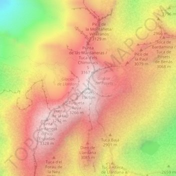
Name: Posets topographic map, elevation, terrain.

Location: Posets, Sahún, La Ribagorza, Huesca, Aragón, 22469, España (42.65458 0.43517 42.65468 0.43527)

Average elevation: 2,892 m

Minimum elevation: 2,137 m

Maximum elevation: 3,361 m

Gear up for your next adventure:

🎒Backpack Rain Cover - External shield to keep your entire pack dry
🛶Kayak Dry Bag - Waterproof storage for kayaking adventures
🧢Beanie Hat - Keep your head warm in cold weather
🎒Hiking Daypack - Lightweight and durable backpacks for day trips and excursions
🥾Trail Hiking Boots - Supportive boots for rough trails

As an Amazon Associate, this site earns from qualifying purchases at no extra cost to you.