Geolocate

Mampang topographic map

Click on the map to display elevation.

About this map

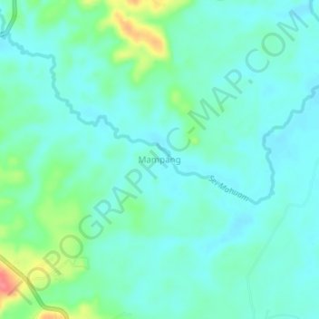
Name: Mampang topographic map, elevation, terrain.

Location: Mampang, South Labuhanbatu, North Sumatra, Sumatra, Indonesia (1.80624 100.01699 1.84624 100.05699)

Average elevation: 24 m

Minimum elevation: 8 m

Maximum elevation: 77 m

Other topographic maps

Click on a map to view its topography, its elevation and its terrain.

Cikampak

Indonesia > North Sumatra > South Labuhanbatu

Average elevation: 56 m

Gear up for your next adventure:

🔦LED Headtorch - Bright and durable light for night activities
👟Leg Gaiters - Keep debris, mud, and snow out of your boots
🥾Hiking Shoes - Durable and comfortable shoes for trail hiking
🧥Thermal Layer - Insulating layer for cold outdoor conditions
🦟Insect Repellent - Keep mosquitoes and black flies away in wooded areas

As an Amazon Associate, this site earns from qualifying purchases at no extra cost to you.