Geolocate

Dickson topographic map

Click on the map to display elevation.

About this map

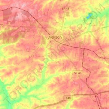
Name: Dickson topographic map, elevation, terrain.

Location: Dickson, Dickson County, Tennessee, 37055, United States (36.00447 -87.42991 36.11386 -87.31250)

Average elevation: 241 m

Minimum elevation: 151 m

Maximum elevation: 295 m

Gear up for your next adventure:

🚲Handlebar Phone Mount - View topographic-map.com live while cycling
🥾Trail Hiking Boots - Supportive boots for rough trails
🦶Hiking Shoe Insoles - Added support for high arches and long days on feet
🧢Sun Hat - Wide-brim hat for sun protection
🥾Lightweight Hiking Boots - Boots for comfort and mobility on long hikes

As an Amazon Associate, this site earns from qualifying purchases at no extra cost to you.