Geolocate

Terrell County topographic map

Click on the map to display elevation.

About this map

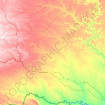
Name: Terrell County topographic map, elevation, terrain.

Location: Terrell County, Texas, United States (29.77909 -102.56698 30.65836 -101.64626)

Average elevation: 739 m

Minimum elevation: 360 m

Maximum elevation: 1,218 m

Other topographic maps

Click on a map to view its topography, its elevation and its terrain.

Sanderson

United States > Texas > Terrell County

Average elevation: 901 m

Sanderson

United States > Texas > Terrell County

Average elevation: 901 m

Gear up for your next adventure:

🧰Emergency Multi-Tool - Compact multi-tool for outdoor survival
🛁Quick-Dry Microfiber Towel - Space-saving towel that dries rapidly on the move
🥾Durable Hiking Shoes - Long-lasting shoes for frequent hiking
🥾Trekking Poles - Adjustable trekking poles to reduce knee stress and improve stability
🛏️Camping Sleeping Mat - Comfortable mats for sleeping outdoors

As an Amazon Associate, this site earns from qualifying purchases at no extra cost to you.