
Thank you for supporting this site ❤️
Make a donation
Make a donation
Gear up for your next adventure:
As an Amazon Associate, this site earns from qualifying purchases at no extra cost to you.
Filettole topographic map
Click on the map to display elevation.
Thank you for supporting this site ❤️
Make a donation
Make a donation
Gear up for your next adventure:
As an Amazon Associate, this site earns from qualifying purchases at no extra cost to you.
About this map
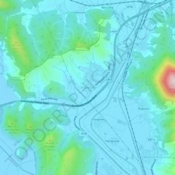
Name: Filettole topographic map, elevation, terrain.
Location: Filettole, Vecchiano, Pisa, Toscana, 55050, Italia (43.79092 10.38094 43.83092 10.42094)
Average elevation: 57 m
Minimum elevation: -5 m
Maximum elevation: 443 m
Thank you for supporting this site ❤️
Make a donation
Make a donation
Gear up for your next adventure:
As an Amazon Associate, this site earns from qualifying purchases at no extra cost to you.