Geolocate

Yzeron topographic map

Click on the map to display elevation.

Yzeron

Yzeron est une commune française, située à 700 m d'altitude dans le département du Rhône en région Auvergne-Rhône-Alpes.

About this map

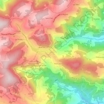
Name: Yzeron topographic map, elevation, terrain.

Location: Yzeron, Lyon, Rhône, Circonscription départementale du Rhône, Auvergne-Rhône-Alpes, France métropolitaine, 69510, France (45.68785 4.57061 45.72785 4.61061)

Average elevation: 703 m

Minimum elevation: 416 m

Maximum elevation: 909 m

Gear up for your next adventure:

🧢Beanie Hat - Keep your head warm in cold weather
🧦Thermal Socks - Warm socks for winter hiking or camping
🧭Orienteering Kit - Tools for map reading and navigation in the wild
🔭Compact Binoculars - Lightweight optics for scouting trails and wildlife
Camping Coffee Maker - Brew fresh coffee anywhere on the topographic map

As an Amazon Associate, this site earns from qualifying purchases at no extra cost to you.