
Thank you for supporting this site ❤️
Make a donation
Make a donation
Gear up for your next adventure:
As an Amazon Associate, this site earns from qualifying purchases at no extra cost to you.
Scandinavian topographic map
Click on the map to display elevation.
Thank you for supporting this site ❤️
Make a donation
Make a donation
Gear up for your next adventure:
As an Amazon Associate, this site earns from qualifying purchases at no extra cost to you.
About this map
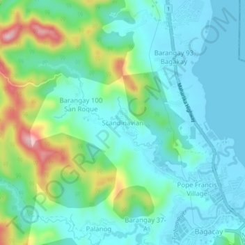
Name: Scandinavian topographic map, elevation, terrain.
Location: Scandinavian, Tacloban, Eastern Visayas, 06500, Philippines (11.25181 124.93062 11.29181 124.97062)
Average elevation: 59 m
Minimum elevation: -1 m
Maximum elevation: 248 m
Thank you for supporting this site ❤️
Make a donation
Make a donation
Gear up for your next adventure:
As an Amazon Associate, this site earns from qualifying purchases at no extra cost to you.