
Make a donation
Gear up for your next adventure:
As an Amazon Associate, this site earns from qualifying purchases at no extra cost to you.
Ipf topographic map
Click on the map to display elevation.
Make a donation
Gear up for your next adventure:
As an Amazon Associate, this site earns from qualifying purchases at no extra cost to you.
Ipf
Der Ipf besteht vorwiegend aus Kalksteinen und Mergeln des oberen Süddeutschen Jura (Weißjura). Die Schichtenfolge des Weißjura ist vollständig. Die sanft zum Ipf ansteigenden Hänge und der Fuß des Berges sind aus Sandsteinen, oolithischen Kalksteinen und Tonsteinen des höheren mittleren Süddeutschen Jura (Braunjura), unter anderem dem sogenannten Eisensandstein und Ornatenton aufgebaut. In der weiteren Umgebung des Berges steht der sogenannte Opalinuston des untersten Braunjura (Braunjura α, Aalenium) an.
Make a donation
Gear up for your next adventure:
As an Amazon Associate, this site earns from qualifying purchases at no extra cost to you.
About this map
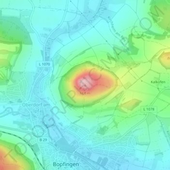
Name: Ipf topographic map, elevation, terrain.
Average elevation: 505 m
Minimum elevation: 457 m
Maximum elevation: 674 m
Make a donation
Gear up for your next adventure:
As an Amazon Associate, this site earns from qualifying purchases at no extra cost to you.