
Lienz topographic map
Interactive map
Click on the map to display elevation.
About this map
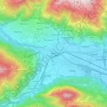
Name: Lienz topographic map, elevation, terrain.
Location: Lienz, Bezirk Lienz, 9900, Autriche (46.81399 12.69537 46.84517 12.80862)
Average elevation: 1,072 m
Minimum elevation: 654 m
Maximum elevation: 2,026 m
Lienz est une ville autrichienne, située dans le Tyrol, à 673 m d'altitude. Elle est le chef-lieu du district de Lienz, formant le Tyrol oriental, territoire resté pratiquement isolé de la province centrale du Tyrol depuis 1919, date du rattachement du Tyrol du Sud à l'Italie.
Other topographic maps
Click on a map to view its topography, its elevation and its terrain.
Nußdorf-Debant
Nußdorf-Debant, Bezirk Lienz, 9990, Autriche
Average elevation: 1,741 m
Gripp
Autriche > Bezirk Lienz > Obertilliach
Gripp, Obertilliach, Bezirk Lienz, 9942, Autriche
Average elevation: 1,796 m