Geolocate

Jesús María topographic map

Click on the map to display elevation.

About this map

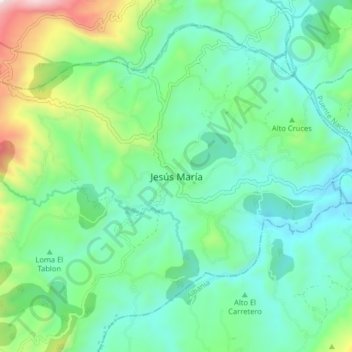
Name: Jesús María topographic map, elevation, terrain.

Location: Jesús María, Vélez, Santander, Colombia (5.83656 -73.82278 5.91656 -73.74278)

Average elevation: 1,901 m

Minimum elevation: 1,642 m

Maximum elevation: 2,698 m

Gear up for your next adventure:

💡LED Headlamp - Hands-free illumination for night hiking and camping
💧Hydration Bladder - Hands-free hydration solution for long treks
🔦LED Headtorch - Bright and durable light for night activities
🧢Sun Hat - Wide-brim hat for sun protection
🧭GPS Tracker - Track your location in remote areas safely

As an Amazon Associate, this site earns from qualifying purchases at no extra cost to you.