
City of Tshwane Metropolitan Municipality topographic map
Interactive map
Click on the map to display elevation.
About this map
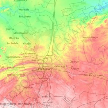
Name: City of Tshwane Metropolitan Municipality topographic map, elevation, terrain.
Average elevation: 1,288 m
Minimum elevation: 938 m
Maximum elevation: 1,798 m
Other topographic maps
Click on a map to view its topography, its elevation and its terrain.
Sedibeng District Municipality
Sedibeng District Municipality, Gauteng, South Africa
Average elevation: 1,554 m
City of Ekurhuleni Metropolitan Municipality
City of Ekurhuleni Metropolitan Municipality, Gauteng, South Africa
Average elevation: 1,588 m
Germiston
South Africa > Gauteng > City of Ekurhuleni Metropolitan Municipality
Germiston, City of Ekurhuleni Metropolitan Municipality, Gauteng, 1401, South Africa
Average elevation: 1,635 m
Roodepoort
South Africa > Gauteng > City of Johannesburg Metropolitan Municipality
Roodepoort, City of Johannesburg Metropolitan Municipality, Gauteng, South Africa
Average elevation: 1,593 m
Himalya Street Park
South Africa > Gauteng > City of Tshwane Metropolitan Municipality > Pretoria
Himalya Street Park, Laudium, Pretoria, City of Tshwane Metropolitan Municipality, Gauteng, South Africa
Average elevation: 1,456 m
Pretoria
South Africa > Gauteng > City of Tshwane Metropolitan Municipality
Pretoria, City of Tshwane Metropolitan Municipality, Gauteng, 0126, South Africa
Average elevation: 1,363 m
Roodepoort
South Africa > Gauteng > City of Johannesburg Metropolitan Municipality > Roodepoort
Roodepoort, City of Johannesburg Metropolitan Municipality, Gauteng, 1850, South Africa
Average elevation: 1,612 m
City of Johannesburg Metropolitan Municipality
South Africa > Gauteng > City of Johannesburg Metropolitan Municipality
City of Johannesburg Metropolitan Municipality, Gauteng, 2904, South Africa
Average elevation: 1,615 m
Johannesburg
South Africa > Gauteng > City of Johannesburg Metropolitan Municipality
Johannesburg, City of Johannesburg Metropolitan Municipality, Gauteng, 2001, South Africa
Average elevation: 1,615 m
Benoni
South Africa > Gauteng > City of Ekurhuleni Metropolitan Municipality
Benoni, City of Ekurhuleni Metropolitan Municipality, Gauteng, 1500, South Africa
Average elevation: 1,645 m
City of Johannesburg Metropolitan Municipality
City of Johannesburg Metropolitan Municipality, Gauteng, South Africa
Average elevation: 1,582 m
Boksburg
South Africa > Gauteng > City of Ekurhuleni Metropolitan Municipality
Boksburg, City of Ekurhuleni Metropolitan Municipality, Gauteng, 1459, South Africa
Average elevation: 1,637 m
Sedibeng
South Africa > Gauteng > Midvaal Local Municipality
Sedibeng, Midvaal Local Municipality, Sedibeng District Municipality, Gauteng, South Africa
Average elevation: 1,514 m