Geolocate

Aubel topographic map

Click on the map to display elevation.

About this map

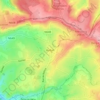
Name: Aubel topographic map, elevation, terrain.

Location: Aubel, Verviers, Liège, Wallonia, 4880, Belgium (50.68415 5.83856 50.72415 5.87856)

Average elevation: 232 m

Minimum elevation: 164 m

Maximum elevation: 292 m

Gear up for your next adventure:

🧭GPS Handheld Device - Reliable GPS navigation for outdoor adventures
🥾Hiking Leggings - Comfortable leggings for outdoor activities
🕯️Camping Lantern - Illuminates your entire campsite with high-efficiency LEDs
🧼Travel Hand Sanitizer - Keep hands clean when water is scarce
🔥Emergency Fire Starter - Reliable ignition source for all weather conditions

As an Amazon Associate, this site earns from qualifying purchases at no extra cost to you.