Geolocate

Ciangir topographic map

Click on the map to display elevation.

About this map

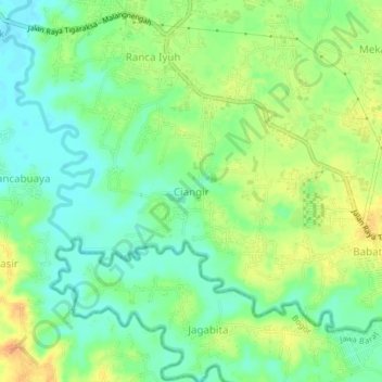
Name: Ciangir topographic map, elevation, terrain.

Location: Ciangir, Tangerang Regency, Banten, Indonesia (-6.33941 106.50745 -6.29941 106.54745)

Average elevation: 40 m

Minimum elevation: 24 m

Maximum elevation: 59 m

Gear up for your next adventure:

🧦Thermal Socks - Warm socks for winter hiking or camping
🚲Heavy Duty Bike Lock - Secure your bike at the trailhead or during stops
🥾Mountain Trail Shoes - High-traction shoes for mountain trails
🌬️Windproof Camp Stove - Efficient cooking even on exposed mountain peaks
🔋Lithium AA Batteries - Long-lasting power that performs in extreme cold

As an Amazon Associate, this site earns from qualifying purchases at no extra cost to you.