Geolocate

Elbe topographic map

Click on the map to display elevation.

About this map

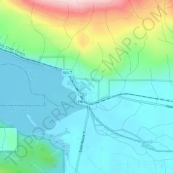
Name: Elbe topographic map, elevation, terrain.

Location: Elbe, Pierce County, Washington, United States (46.76304 -122.19781 46.76848 -122.18991)

Average elevation: 439 m

Minimum elevation: 357 m

Maximum elevation: 695 m

Gear up for your next adventure:

🥾Mountaineering Boots - Supportive boots for climbing and high-altitude hiking
Bushcraft Tarp - Versatile emergency shelter or gear protection
🗺️Topographic Maps - Detailed maps to explore trails, mountains, and wilderness areas
💡Solar Camping Lamp - Eco-friendly lighting for campsites
🥾Light Trekking Boots - Supportive boots for multi-day treks

As an Amazon Associate, this site earns from qualifying purchases at no extra cost to you.