
Make a donation
Gear up for your next adventure:
As an Amazon Associate, this site earns from qualifying purchases at no extra cost to you.
Leipferdingen topographic map
Click on the map to display elevation.
Make a donation
Gear up for your next adventure:
As an Amazon Associate, this site earns from qualifying purchases at no extra cost to you.
About this map
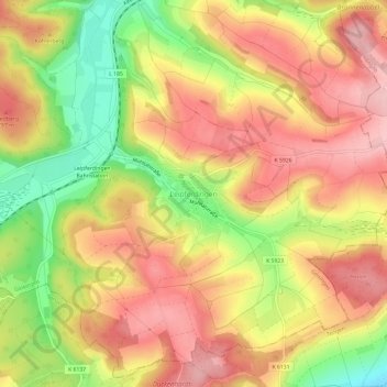
Name: Leipferdingen topographic map, elevation, terrain.
Average elevation: 754 m
Minimum elevation: 653 m
Maximum elevation: 824 m
Make a donation
Gear up for your next adventure:
As an Amazon Associate, this site earns from qualifying purchases at no extra cost to you.
Other topographic maps
Click on a map to view its topography, its elevation and its terrain.
Gutmadingen
Deutschland > Baden-Württemberg > Landkreis Tuttlingen > Geisingen
Average elevation: 743 m
Basaltkegel
Deutschland > Baden-Württemberg > Landkreis Tuttlingen > Geisingen > Leipferdingen
Average elevation: 754 m
78187
Deutschland > Baden-Württemberg > Landkreis Tuttlingen > Geisingen > Kirchen-Hausen
Average elevation: 758 m