Geolocate

Franklin topographic map

Click on the map to display elevation.

About this map

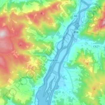
Name: Franklin topographic map, elevation, terrain.

Location: Franklin, Huon Valley, Tasmania, 7113, Australia (-43.12861 146.93369 -43.03360 147.03201)

Average elevation: 186 m

Minimum elevation: -3 m

Maximum elevation: 612 m

Gear up for your next adventure:

🧳Compression Sacks - Maximize space in your backpack by shrinking gear
🚑Survival Whistle - Signal for help across long distances in mountains
🎒Hiking Daypack - Lightweight and durable backpacks for day trips and excursions
💧Reusable Water Bottle - Durable water bottles for hydration on trails
🧥Waterproof Hiking Jacket - Protect yourself from rain and wind while hiking

As an Amazon Associate, this site earns from qualifying purchases at no extra cost to you.