Geolocate

Bielva topographic map

Click on the map to display elevation.

Bielva

Bielva es el nombre del núcleo capital del municipio de Herrerías, en la Comunidad Autónoma de Cantabria (España). Dista unos setenta kilómetros de la capital regional. Tenía en 2008 (INE), 216 habitantes. Se encuentra a 188 metros de altitud.

About this map

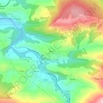
Name: Bielva topographic map, elevation, terrain.

Location: Bielva, Puente El Arrudo, Herrerías, Saja-Nansa, Cantabria, 39550, España (43.29495 -4.48544 43.33495 -4.44544)

Average elevation: 212 m

Minimum elevation: 41 m

Maximum elevation: 488 m

Gear up for your next adventure:

📷Outdoor Action Camera - Capture high-elevation views and rugged adventures
🧢Outdoor Cap - Protective cap for sun and rain during hikes
🔦LED Headlamp - Hands-free lighting for early morning starts or late finishes
🥾Approach Shoes - Shoes designed for climbing approaches and rugged trails
🧭Orienteering Kit - Tools for map reading and navigation in the wild

As an Amazon Associate, this site earns from qualifying purchases at no extra cost to you.