Geolocate

Paite topographic map

Click on the map to display elevation.

About this map

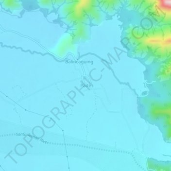
Name: Paite topographic map, elevation, terrain.

Location: Paite, San Narciso, Zambales, Central Luzon, Philippines (15.01794 120.10862 15.05794 120.14862)

Average elevation: 41 m

Minimum elevation: 12 m

Maximum elevation: 386 m

Gear up for your next adventure:

🥾Trail Hiking Shoes - Durable shoes designed for rugged trails
🧰Survival Kit - Essential gear for emergencies in the wilderness
🎒Backpack Rain Cover - External shield to keep your entire pack dry
🧤Thermal Hiking Gloves - Grip-enhanced gloves for cold-weather altitude trekking
📷Outdoor Action Camera - Capture high-elevation views and rugged adventures

As an Amazon Associate, this site earns from qualifying purchases at no extra cost to you.