
Make a donation
Gear up for your next adventure:
As an Amazon Associate, this site earns from qualifying purchases at no extra cost to you.
Fürstenhagen topographic map
Click on the map to display elevation.
Make a donation
Gear up for your next adventure:
As an Amazon Associate, this site earns from qualifying purchases at no extra cost to you.
About this map
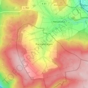
Name: Fürstenhagen topographic map, elevation, terrain.
Average elevation: 283 m
Minimum elevation: 121 m
Maximum elevation: 391 m
Make a donation
Gear up for your next adventure:
As an Amazon Associate, this site earns from qualifying purchases at no extra cost to you.
Other topographic maps
Click on a map to view its topography, its elevation and its terrain.
Gierswalde
Deutschland > Niedersachsen > Landkreis Northeim > Uslar
In der Nähe des Überschwemmungsgebietes des Rehbaches steht die, wahrscheinlich im 14. Jahrhundert errichtete, Kapelle von Gierswalde. Sie besitzt einen schwach rechteckigen Grundriss in den Ausmaßen von 9 m mal 6,85 m, wuchtige Eckquader und eine Höhe von 8 m bis zur Dachtraufe. Die, mit rotem Sandstein…
Average elevation: 272 m
Schoningen
Deutschland > Niedersachsen > Landkreis Northeim > Uslar
Schoningen liegt etwa 4 km südsüdöstlich von Uslar und 7 km (je Luftlinie) östlich des an der Weser gelegenen Bodenfelde. Das Dorf befindet sich an den Südausläufern des Mittelgebirges Solling an der Mündung des Rehbachs in die Ahle, der etwa 1 km weiter südlich in die Schwülme mündet. Schoningen ist…
Average elevation: 211 m